Page 1 of 2
ST GEORGES WAY,
Posted: Tue Jul 31, 2018 5:12 am
by kiwi

- St George’s Way in 1978, was called St Georges Road. Runs between Wells Way and Trafalgar Avenue.

- St Georges Way, The George and Dragon Pub. I think the turning right was called Birdlip Close? and Opposite St Georges Church Yard. The pub has now been demolished.

- C1961.
Re: ST GEORGES WAY,
Posted: Thu Mar 21, 2019 3:28 pm
by profjohn
Hi there - the road to the right is Dargon Rd (hence George & Dragon pub!). I lived other end of the Dragon Rd loop 1953-60 then moved round the corner to St Georges Way 1960-67 then we were then rehoused due to the clearance. Dragon Rd disappeared with the building of the Nth Peckham Estate but it's now reinstated following the latter's demise! John
Re: ST GEORGES WAY,
Posted: Thu Mar 21, 2019 11:40 pm
by kiwi
Hi John (profjohn) welcome to the site and thanks for the information. Did you mean the road to the right is/was Dragon Rd not Dargon Road? I thought it might be Birdlip Close but that was probable further back towards Wells Way,so thanks for putting me right. As you say it has changed so much in that area and Dragon Road is now further back. Am I right that the corner where the pub was is now called Comfort Street.? Ray (kiwi).
Re: ST GEORGES WAY,
Posted: Tue May 19, 2020 2:14 am
by kiwi

- St Georges Way, view from corner of Trafalgar Avenue c1954.
Re: ST GEORGES WAY,
Posted: Sat May 23, 2020 3:51 am
by kiwi

- St Georges Way, late 1970.
Re: ST GEORGES WAY.
Posted: Tue Sep 29, 2020 4:21 am
by kiwi
- 79 St Georges Way.
St Georges Way 2019, roughly the same location as the picture above. The bridge to nowhere is now in Burgess Park.
A better picture of the bridge can be seen in the Albany Road Topic (page2).
Re: ST GEORGES WAY,
Posted: Mon Jan 04, 2021 3:15 am
by kiwi

- St Georges Way,1979.

- St Georges Way (left), from Wells Way 2020. Same location.
Re: ST GEORGES WAY,
Posted: Tue Jan 26, 2021 11:59 pm
by kiwi

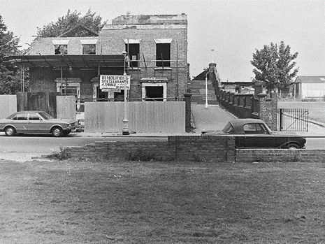
- St Georges Way, Surrey Canal Bridge, c1979. Now Burgess Park.

- St Georges Way, c1979, same location.
Re: ST GEORGES WAY,
Posted: Sat Mar 27, 2021 9:24 am
by kiwi
A screen from the 1962 Walworth School film "Two Bob's Worth of Trouble". The 'totter' was 'Ribena' Wallington and his wife Dorothy.

- St George's Way. 1962. The pub on the right is the Prince of Wales on the corner with Castlemain Road and leading to Gloucester Grove both no longer there.

- St George's Way 1962. The picture was taken from the footbridge leading to Neate Street which is now in Burgess Park (picture above). The houses in front have been replaced by Gloucester Grove Estate c1978.
Re: ST GEORGES WAY,
Posted: Sat Jun 12, 2021 7:17 am
by kiwi
I think this is the same bridge same location as the picture above, coming out at St Georges Way, it looks similar. The other end as I remember it came out in Neate Street opposite The Queen Pub?

- Neate Street Bridge, Camberwell, c1970.